Images from San Diego fires - Sunday 26th, October 2003.
For
information, questions or comments please contact Stephen Akers
Photography at 619.284.2154 or send email.
(click images to view.)
 |
 |
 |
 |
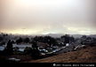 |
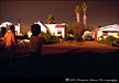
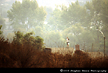
| Smoke plume covering San Diego - 5:45am, my neighbors, Amy and I looking west - 33rd Street, Normal Heights. | Smoke plume covering San Diego - looking east - 33rd Street, Normal Heights. | Smoke plume covering San Diego - Normal Heights. | Smoke plume covering San Diego - Normal Heights. | Smoke plume from Otay fire near border - 9:30am view from Santee. |
 |
 |
 |
 |
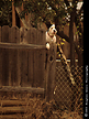 |
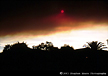
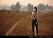
| Santee resident looking west as fire engulfs the hills behind his home. | Fire burning hills southwest of Santee. | Amy looking west at the hills burning. | West of Santee the fire burns through grass and brush heading southwest towards San Diego. | Some animals around the fire ravaged area were left behind as home owners panicked to get out. In this case, the homeowner was on his roof watering down the structure. |
 |
 |
 |
 |
 |
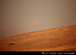
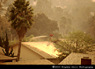
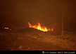
| Some homeowners in Santee refused to leave under the mandatory evacuation wanting to stay and protect their homes. | Fire burning through grasses and edging closer to the homes of Santee. | Santee resident walks her horse awaiting transportation. | Santee resident gathering food for her animals. | South of Santee the fire jumps highway 52 and rages through Mission Trails Regional Park. |
 |
 |
 |
 |
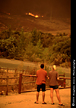
|
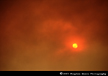
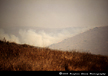
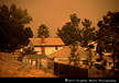
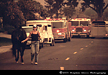
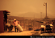
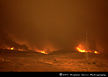
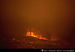
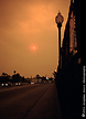
| Fire raging through Mission Trails Regional Park creates flames that reach 100 to 150 feet. | Heading southwest and burning through heavy brush, the fire threatens communities southwest of Mission Trails Regional Park. | Locals watch the fire spread through Mission Trails. A subdivision stand just behind this couple (and me) about 100 yards. | 3:30pm Sunday the fires smoke plumes block out the sun and drop ash on San Diego - Adams Avenue and the 805 bridge. |
![]()